 |
| Frijoles Canyon |
fire?"
Yes, it is open. The area suffered massive damage in 2011, but it has stabilized and is recovering.
In June 2011, the Las Conchas Fire burned 156,000 acres including much of Bandelier. A whopping 75% of Frijoles Canyon was impacted by the fire. The fire started with a single tree falling on a power line. Burning through roughly an acre a second, it is (at this writing) the largest in the history of New Mexico.
Almost two years later, you can see the ravages -- and the recovery. There are acres of felled trees, scorched lands and stumps. We could see the fire line, where the fire touched but then didn't cross, the road. We saw tall, thin trees that are taking root and underbrush returning. Some of the displaced wildlife is returning. Other wildlife is returning more slowly, if at all.
With the natural buffer to flooding devastated, Bandelier suffered a flash flood just two months later. Sandbags are piled around rear of the visitor center, signs posting high water marks and warnings of flash floods. It is clear that this area suffered and is still at risk.
For us, however, it was a cool day with some wind and drizzle, but no fires or floods. The park rangers were friendly and helpful, the main trails were open, and the dwellings were accessible.
On the days when we break camp, it seems we no sooner leave the campsite and arrive at our destination than it is time to eat again. This day was no exception. We got up, ate breakfast, took down the tents, loaded the car, and arrived at Bandelier in time for lunch.

The night before we'd been having problems with our stove. Now I like good food as much as the next person, but if push comes to shove, I'll eat a peanut butter & jelly sandwich for three meals in row. Manuel, however, takes his meals a little more seriously.
He worked on the stove for at least an hour night before and, when it didn't respond, he brought pizza back to the camp. In the morning, I awoke thinking I'd bring them out to breakfast, and he awoke committed to fixing the stove. He did fix it, and, as a result, we had eggs for breakfast and what would have been the previous night's dinner for lunch.

When we were well-fueled, we were ready to explore the area.

We were excited to go inside some of the dwellings.

It was cool and breezy, and turned colder and windier, while we were exploring Bandelier. The blurry lines in this photo are what you can see of the fine sand being thrown by the wind.
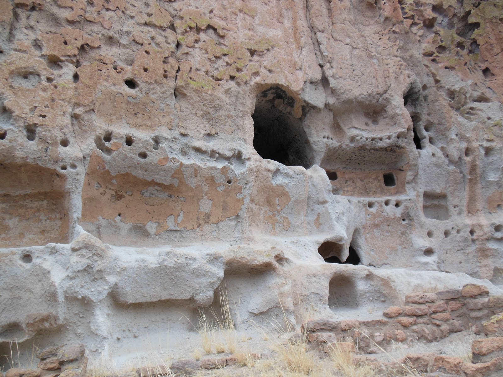
The wind and the erosive nature of tuff (the hardened volcanic ash in which the dwellings are carved) make it necessary to apply some kind of coating to the harden the walls and floors. In this photo, the convex curves represent the interior walls of the dwellings. They are coated with a kind of plaster to keep them firm. On the floor, the Ancestral Pueblo put a coating which incorporated the blood of animals which, when dried, would make a hard finish. The holes you see along the leading edge are the holes which held the vegas (or rafters) for the ceiling.

This is a preserved piece of wall from the interior of the dwelling. To see it was a pleasant surprise and brought a richness to our imaginations about the everyday lives of the people who lived there.
It isn't often that the kids are excited about walking further, but we were all eager to see the Alcove House just a half a mile further down the trail. Formerly called the Ceremonial Cave, it is believed to have been a spiritual and ceremonial center of the Pueblo.
 |
| The Alcove House is in the large cave in the top right. If you look closely, you'll see the ladders to climb up to the left. |
 |
| Looking out from the Alcove House. The kiva is on the left. |
It was 4pm when we headed home. Just enough time for one last stop.

White Rock Overlook: it is a place to stop and take in the immensity of where you are and where you've been. Dropping 1000 feet to the canyon floor, you can see the Rio Grande, mesas, and the snow-capped Sangre de Cristo Mountains in the distance.
Wondering how we balance work with life on the road? click here.
wow. So impressive. Both the cliffside living and the grand scenery. The Pueblo must have been familiar with "Location, Location, Location" when selecting their cliffside homesites! :)
ReplyDeleteTruly is amazing. The vista and history so remarkably different than what we are used to. Wonderful experience.
DeleteSuch a wonderful reminder of how truly vast and beautiful this country really is when you take the time to step back and look at it --- what a treasure you're giving your boys.
ReplyDeleteThanks, Molly. We feel pretty fortunate to have the opportunity to explore! I remember one road schooling mom who wrote about her kids learning about 'purple mountain majesties' by experiencing them. I find that pretty inspiring.
DeleteAwesome, maybe some day I can visit the world "outside myself"
ReplyDeleteMaybe one day I can visit the wonders of the world. Right now I am wondering about the vastness of my own mind. Hop I don't get lost! LOL
ReplyDelete